Math questions / Topography
Architectural Topic:
Topography
Math skills:
graphical analysis Math courses:
Does the design of the school pay attention to the landscape or ignore it?
How does topography influence the way a building is designed to sit on the site?
The topography, the height and shape of the land either natural or manipulated, will have an impact on the way the school building is designed to site on the site. At the Nueva School, which was constructed on an existing sloping site, the architects and landscape architects tried to minimize the amount of earth moved during construction by integrating the buildings into the landscape.
Study this topographic map below of the Nueva School site that shows the height and shape of the land. Each curved contour line on the map represents an imaginary line on the earth’s surface which notes similar heights on the surface of the land.
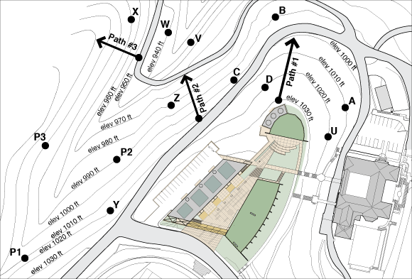
1.
Each contour line on a topographic map has exactly the same elevation or vertical distance. Locate point A on the site map for the Nueva School. Find the place along this contour line where the elevation is shown. What is the elevation of point A?
2.
What is the elevation of point B?
3.
What is the elevation of point C?
4.
Points B and C are approximately the same distance away from point A. Which represents a steeper path? Traveling directly from point B to A or from C to A?
5.
Is it steeper where the contour lines are closer together or farther apart?
6.
On the site map of the Nueva School, put the three points (P1, P2, P3) in order of elevation from lowest to highest.
7.
On the site map, six points, labeled U, V, W, X, Y, and Z are marked. Which points are at the same elevation? (There are 3 pairs total.)
8.
Suppose that the soccer coach of the Nueva School really wants the team to exercise their calf muscles, so she wants them to run up and down the steepest part of the hill adjacent to the school’s property. Since the site includes bushes and other hazards, the coach has picked 3 possible paths to run the hills. These paths are marked on the map with arrows (#1 – #3). Which path is the steepest? How can you tell from the contour map?
9.
Contour maps allow us to see a representation of three variables. What are these three variables?
10.
Explain why the contours on this topographic map drawn below cannot be correct.
[diagram still to come]