Math questions / Sun path
Architectural Topic:
Climate and Sun Path
Math skills:
graphical analysis, data analysis Math courses:
How can a school be positioned on its site to take advantage of the path of the sun?
In the northern hemisphere, the path of the sun in the sky is higher in the summer and at it highest point at the summer solstice on June 21, the first day of summer. The path of the sun in the sky is lower in the winter and at its lowest point at the winter solstice on December 21, the first day of winter.
Architects and engineers use sun path diagrams (see examples below) to help illustrate the path of the sun in our sky. The blue arc indicates the path of the sun in the summer (blue; because buildings typically require cooling in summer months). The red arc indicates the path of the sun in the winter (red; because buildings typically require heating in winter months).
The path of the sun is important to consider when designing buildings because architects and engineers want to maximize the positive impact (such as human comfort and energy savings) of sunlight on a building.
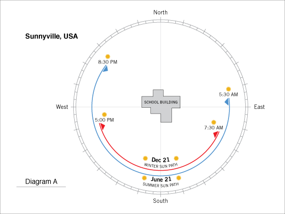
Use Diagram A, showing the imaginary town of Sunnyville, USA, to answer the questions below.
1.
What time is sunrise on June 21 in Sunnyville?
2.
What time is sunset on June 21 in Sunnyville?
3.
How many total hours of sunlight does Sunnyville receive on June 21?
4.
How many total hours of sunlight does Sunnyville receive on December 21?
5.
How many more hours of sunlight does Sunnyville enjoy on June 21 than on December 21 each year?
6.
Suppose that the principal of Sunnyville High School arrives at the school each day at 6:45am. Is she ever traveling to school in the dark? Explain your answer.
7.
Is she always traveling to school in the dark? Explain your answer.
8.
On St. Patrick’s Day (March 17) in Sunnyville, the sun rises at 6:52 am and sets at 6:45 pm. On Diagram A, sketch the arc representing the sun path and the amount of sunlight on St. Patrick’s Day.
Use Diagram B, Diagram C, and Diagram D to answer the questions below. Diagram B illustrates the path of the sun in the sky of New York City as well the sunrise and sunset times for June 21 and December 21. Diagram C and Diagram D also illustrate New York City, but are missing dates. Match the possible dates below with the approximate diagram. You will not use all the answers.
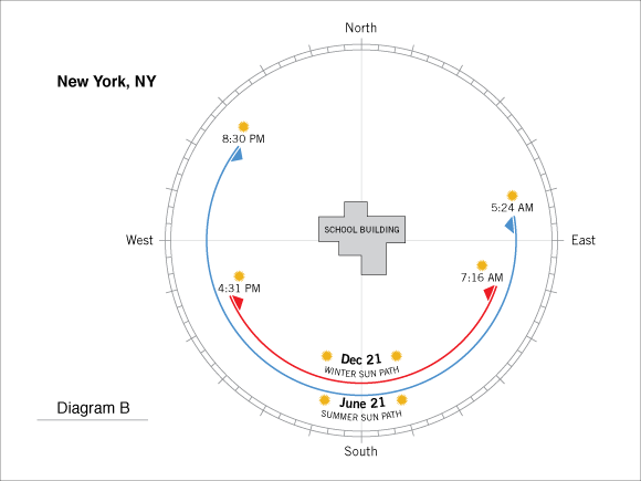
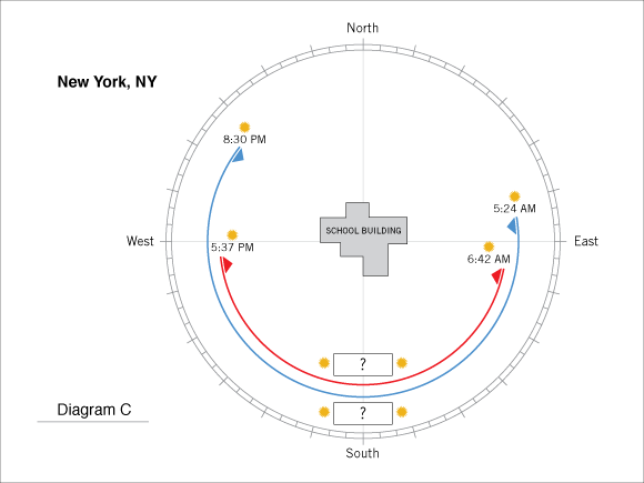
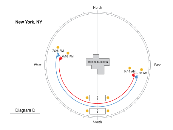
9a.
March 21 and September 23
9b.
November 15 and December 21
9c.
June 21 and August 1
10.
In Diagram D, the two arcs are almost the same length. What does this tell you about the amount of sunlight in New York City on those two days? Explain your answer.
Use Diagram E illustrating the sun path in Boca Raton, Florida to answer the questions below. Complete Diagram E by adding the dates and sunrise and sunset times in the proper locations.
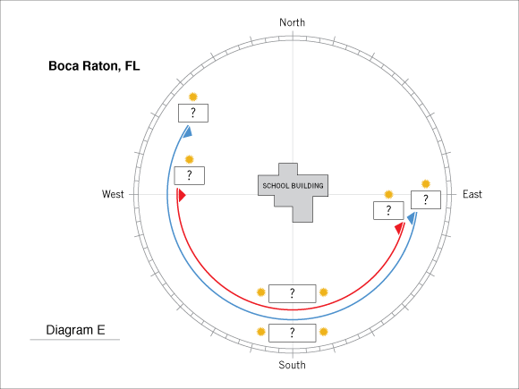
11a.
February 14 sunrise 6:57 am
11b.
February 14 sunset 6:12 pm
11c.
July 4 sunrise 6:32 am
11d.
July 4 sunset 8:17 pm
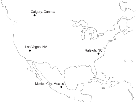
The total number of hours of sunlight a geographic location receives on a particular day of the year depends on its distance from the equator. The chart below lists the sunrise and sunset times and distance north of the equator for four North American cities on February 2 (Groundhog Day). Use this data to answer the questions below.
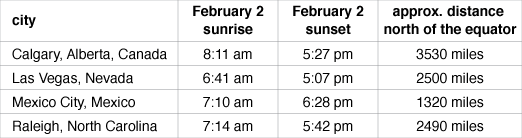
12.
Calculate the total hours and minutes of sunlight in each city on February 2.
13.
Which city on the chart receives the least amount of sunlight on February 2?
14.
How do you think the distance from the equator impacts the amount of sunlight received in particular North American location on February 2?
15.
Which two cities have very similar amounts of sunlight on February 2? Why do you think this is the case?
16.
Each of the four cities listed in the chart are far apart from each other. For example, Raleigh, North Carolina is approximately 1300 miles east of Las Vegas, Nevada. Why doesn’t the east or west position of the cities affect the total amount of sunlight received?
Use Diagram F – Diagram I to answer the questions below. The diagrams represent the sunrise and sunset times for Calgary, Alberta; Las Vegas, Nevada; Mexico City, Mexico; and Raleigh, North Carolina.
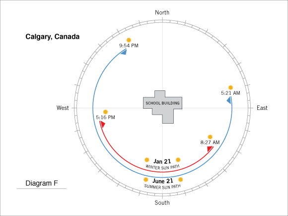
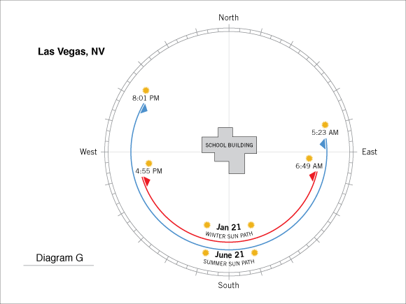
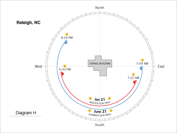
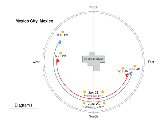
17.
Which of the four cities receives the most sunlight on June 21?
18.
Which of the four cities receives the least amount of sunlight on December 21?
19.
Based on your answer to question 18, is this city closer or farther from the equator than the other three cities?
20.
As you move closer to the equator, what happens to the difference in the amount of sunlight between the longest day of the year (June 21) and shortest day of the year (December 21)?
21.
Based on your answer to question 20, sketch a sun path diagram for a city that has practically the same amount of sunlight between June 21 and December 21?
Math image


