Math questions / Wind
Architectural Topic:
Climate and Sun Path
Math skills:
graphical analysis, data analysis Math courses:
How can a school be positioned on its site to take advantage of wind and the best views?
Meteorologists, architects, and engineers often use a diagram called a wind rose to visualize the frequency of wind direction at a particular location. The data contained in a wind rose helps architects and engineers understand the existing conditions at a particular site. When determining the position of a new building on a site, they want to situate the building in such a way that will maximize the direction and velocity (speed) of the wind, allowing for the best natural cooling breezes.
Imagine a circle cut into eight sectors or wedges. Like a compass rose, the top sector (or wedge) on a wind rose represents north. In this case, the wind rose illustrates that the wind from the north blowing to south. Similarly, a sector to the right indicates that wind is coming from the east and blowing to the west.
A sector that is enlarged (or lengthened) means that the wind comes from that direction more often; a short (or squashed) sector means the wind does not come from that direction very often.
The individual sectors are also divided to show wind speed as well as direction. Each portion of the sector is shaded or colored to indict a particular range of speeds. Percentages for the lower speeds are shown closer to the center of the diagram. The high speed winds are shown further from the center.
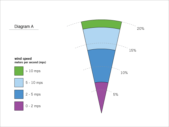
Use Diagram A, a wind rose for the imaginary town of Middlefield, USA to answer the questions below. This particular wind rose sector indicates wind (measured in meters per second, or mps) coming from the north. It illustrates that about 20% of the time, the wind in Middlefield comes from the north.
1.
About what percent of the wind in Middlefield comes from the north at 0 - 2 mps?
2.
The percent of wind in Middlefield that comes from the north at 10 mps or greater, is neither 18% nor 20%, but about 2%. About what percent of the wind in Middlefield comes from the north at speeds of 2 - 5 mps?
3.
About what percent of the wind in Middlefield comes from the north at speeds of 5 -10 mps?
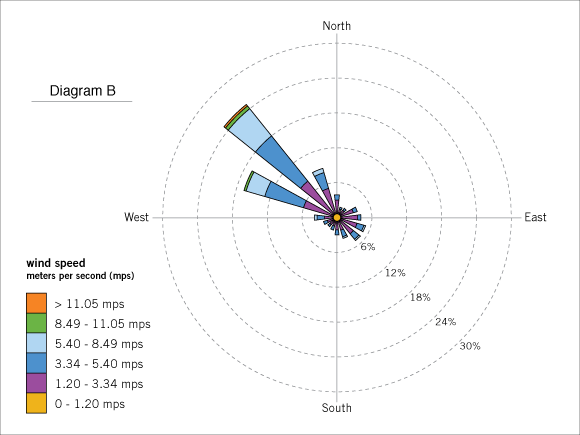
Use Diagram B, a wind rose illustrating the direction and velocity (speed) of wind in Fresno, California, to answer the questions below.
4.
In general, which direction does the wind typically come from in Fresno? How can you tell?
5.
About what percent of the wind in Fresno, California comes from the northwest
6.
About what percent of Fresno’s wind comes from the northwest at 5.4 – 8.49 mps?
7.
Which direction provides the second highest percent of the total wind in Fresno?
8.
Which direction provides the third highest percent of the total wind in Fresno?
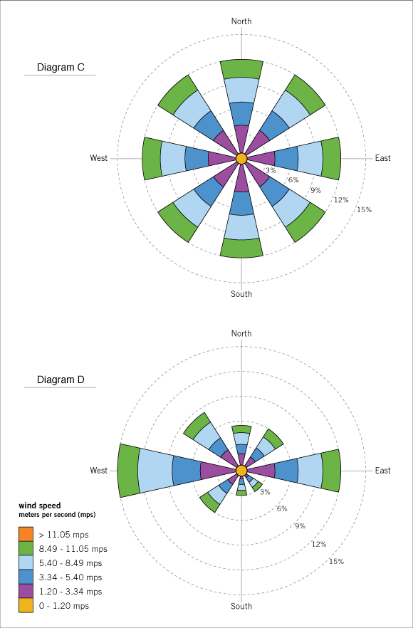
Use Diagram C and Diagram D, wind roses illustrating two different locations across the country, to answer the questions below.
9.
Describe the differences in the wind direction and velocity (speed) at these two locations.
10.
Based on this wind rose data, which location do you think would be a better site to install a wind turbine? Explain your thinking.
Use Diagram E and Diagram F, wind roses illustrating two hypothetical locations across the country, to answer the questions below.
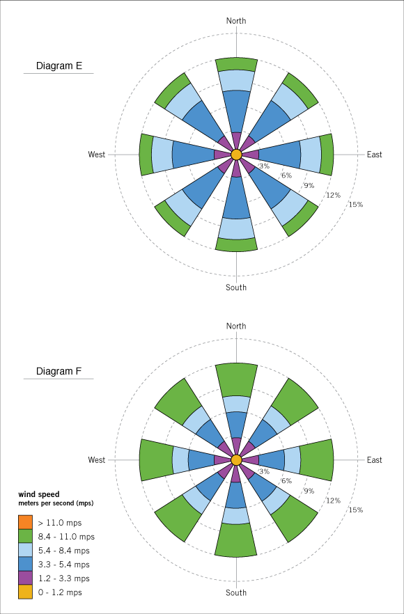
11.
Describe the differences in wind velocity (speed) between Diagram E and Diagram F.
12.
Would you say that most of the wind in Diagram E is gentle or strong? Explain.
13.
Based on this wind rose data, which location do you think would be a better site to install a wind turbine? Explain your thinking.
14.
Explain why the wind roses in Diagram E and Diagram F could not be real.
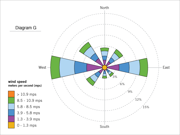
15.
Diagram G illustrates a wind rose for Kansas City, Kansas. Suppose a house is placed at the center of the site. Based on the wind rose data, how should the architect arrange the windows in the house to provide the best cross breezes? Explain your answer.
Use Diagram H, a wind rose for Charlottesville, Virginia, to answer the questions below.
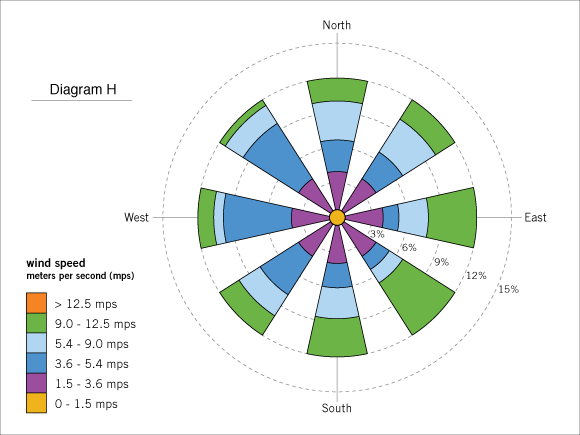
16.
Each direction at this site provides wind about one 1/8 of the time. However, the wind is not the same from every direction. Describe the difference in the wind from different directions.
17.
Suppose a garden is placed at the center of this site. Based on this wind rose data, which side should the gardener place a wind break to block the strongest winds? Explain your answer.
Use Diagram I, a wind rose for a site in southern California, to answer the questions below.
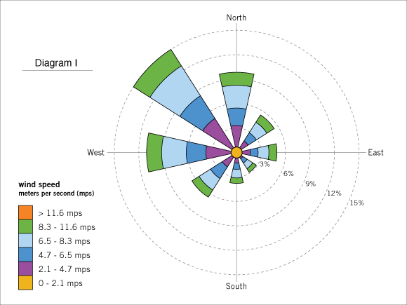
18.
Suppose that a baseball field is to be built next to a new high school in southern California where baseball can be played all year. The coach wants a "hitters’ field". Based on the wind rose data in Diagram I, how should the field be oriented so that the chance of hitting home runs (long fly balls) is maximized? Explain your answer.
19.
Suppose a second baseball field is to be at the elementary school across the street from the high school. Based on the wind rose data in Diagram I, how should the field be oriented so that the small children will be less likely to have to run after fly balls hit over their heads? Explain your answer.
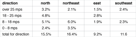
20.
Students at Nebraska high school have been collecting data on the wind velocity (speed) around their school. But some of the information in the following table was smudged and has become illegible. Where possible, determine the correct value for the empty cells in the chart. Explain why values for some of the empty cells cannot be determined.
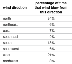
21.
The chart below lists the percentages of wind direction for San Francisco, California in January. Based on this data and what you have learned from the previous problems, sketch a simplified wind rose. Don’t worry about dividing the sectors of the wind rose to indicate the velocity (speed) of the wind.
Math image
")